
Drone Photography for Real Estate: Rules, Costs & Results in QLD
Aerial photography has moved from luxury to expected at the upper end of Brisbane’s listing market — and into the standard toolkit for any property where the block, the view or the street position is a selling point. But drones in Australia operate under CASA regulations that many agents and vendors don’t fully understand, which creates both confusion and risk. This guide covers the rules honestly, the results that justify the investment, and the properties where drone footage earns its place versus the ones where it doesn’t.
What’s in this guide
- CASA rules for commercial drone use in QLD
- Brisbane airspace: what’s affected
- When drone footage actually sells
- When it’s not worth it
- What to ask your videographer before booking
- Frequently asked questions
CASA rules for commercial drone use in QLD
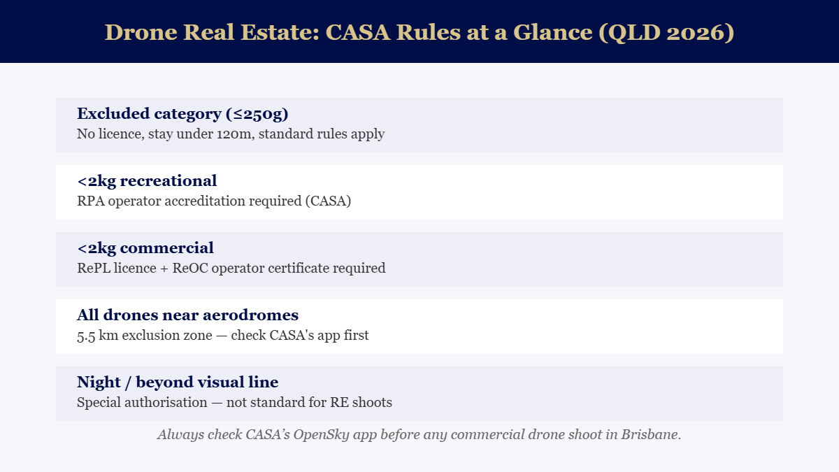
The key distinction is commercial versus recreational. Any drone flight where money changes hands — including the listing fee covering media production — is commercial under CASA’s definitions. That means the operator needs a Remote Pilot Licence (RePL) and their company needs a Remote Operator Certificate (ReOC). The penalties for unlicenced commercial drone operation are substantial, and the insurance consequences of an incident without the right certification can fall on the property owner or agent. Ask for CASA credentials as a routine part of any drone videography booking — a reputable operator will hand them over without hesitation.
Brisbane airspace: what’s affected
Brisbane’s geography creates more airspace complexity than most Queensland cities. Brisbane Airport’s controlled airspace affects properties in the northern and eastern suburbs. Archerfield covers the southern corridor. Redcliffe and Caboolture have smaller exclusion zones affecting their surrounding areas. Properties in Kedron, Nundah, Hendra, Ascot, Hamilton, Bulimba and along the northern river bend often sit close to airspace limits. This doesn’t mean aerials are impossible — it means the operator needs to check the OpenSky app for the specific address, and in some cases apply for authorisation before the shoot can be booked. Our crews do this as a standard pre-production step; we don’t discover the restriction on the day.
When drone footage actually sells
Four property types where drone coverage directly changes buyer behaviour. Large blocks: size is genuinely hard to communicate in stills; an aerial that follows the boundary makes the land real in a way floor plans can’t. Water or park views: the aerial establishes the relationship between the property and the view that makes it valuable — buyers need to see the proximity, not just read it in the description. Desirable streets and suburbs: a slow approach shot down a tree-lined street or along the river positions the lifestyle before the door is even open. Unique or architecturally distinctive homes: form and roofline detail that reads well from above, communicating design intent to buyers who care about it. All four of these are included in our listing packages from the Standard tier up — details and current pricing on our real estate page.
When it’s not worth it
Drone coverage adds cost and shoot complexity; it should earn its place. It generally doesn’t for: mid-floor or high-rise apartments (no block, no streetscape to speak of), properties in dense inner-city blocks where the aerial shows neighbours’ roofs rather than the subject, and listings where the price point doesn’t match the production level buyers expect. An honest conversation about this at the briefing stage is part of our standard process — we’d rather recommend against drone coverage when it won’t add value than bill for it because it’s on a checklist.
What to ask your videographer before booking
Five questions that separate a compliant, professional drone operator from a risk. Are you RePL licenced and does your company hold a ReOC? — ask to see both. Do you carry public liability insurance covering commercial drone operations? — standard coverage is $10–20M in Australia; anything below $5M is under-insured for a residential property context. Have you checked the airspace for this address? — should be done before quoting, not on the morning of the shoot. What’s your weather and wind policy? — a free reschedule clause for wind above limits is standard practice. Who owns the footage? — should be you, in perpetuity, for your marketing use. Book a free consultation or call 07 2142 4335 to discuss a specific listing.
Weather, wind and the day-of decision
Drone shoots in Brisbane have a narrow operational window when conditions aren’t cooperative: wind above 30 km/h, rain, and fog all ground commercial operations under standard certifications. The implication for listing timelines: build in a reschedule buffer, especially for twilight shoots where the weather window and the light window have to align simultaneously. A professional crew should offer a free weather reschedule as standard; if yours doesn’t, it’s worth clarifying before the day-of scramble. Coastal and river properties in Brisbane also face sea-breeze patterns in the afternoon — morning shoots before 10am are often the most reliable window for both ground and aerial work.
How drone footage should be edited into a listing video
The worst use of drone footage is a standalone aerial reel that starts with the drone lifting off a paddock and slowly orbiting the property for ninety seconds. The best use is three to five aerial clips woven into the listing walkthrough: the approach (arriving at the address from above, establishing the street), the position shot (showing the block, the views or the water), and the pullback (revealing the suburb context). These moments take thirty seconds of screen time and do what no interior shot can — they answer the buyer’s instinctive question of “where exactly is this, and what does the neighbourhood feel like?” Cut seamlessly into the ground footage, they make the walkthrough feel cinematic without padding the runtime.
← Explore all our Brisbane marketing guides
Want this handled for you? See our real estate photography & video packages in Brisbane — from $140.
Frequently asked questions
Do you need a drone licence for real estate photography in Australia?
For commercial drone use (any drone flight where the operator or client is paid), you need a Remote Pilot Licence (RePL) and your operating business needs a Remote Operator Certificate (ReOC) from CASA. Exceptions apply for drones under 250g operated under the excluded category rules. Most professional real estate videography uses equipment well above that weight threshold, so always confirm your provider is commercially licenced.
Can drones fly near Brisbane airports?
Not without CASA authorisation. A 5.5 km exclusion zone applies around controlled aerodromes. Brisbane Airport, Archerfield, Redcliffe and Caboolture all have exclusion zones that affect nearby properties. CASA’s OpenSky app shows the airspace classification for any address before a shoot is booked.
How much does drone real estate photography add to a package cost?
Drone coverage is included from the Standard tier up in our real estate packages, which start from $750 (currently half price for first-time agents). It isn’t priced as a standalone add-on in our standard structure — the tiers are designed so you’re not assembling a quote from parts.
When is drone footage not worth it for a listing?
When the property’s position isn’t a selling point. A mid-floor apartment in a uniform block, a suburban block without notable views or size — aerials of these properties often show neighbouring roofs and car parks. Save the drone for blocks where the land size, position, aspect or approach is genuinely compelling.